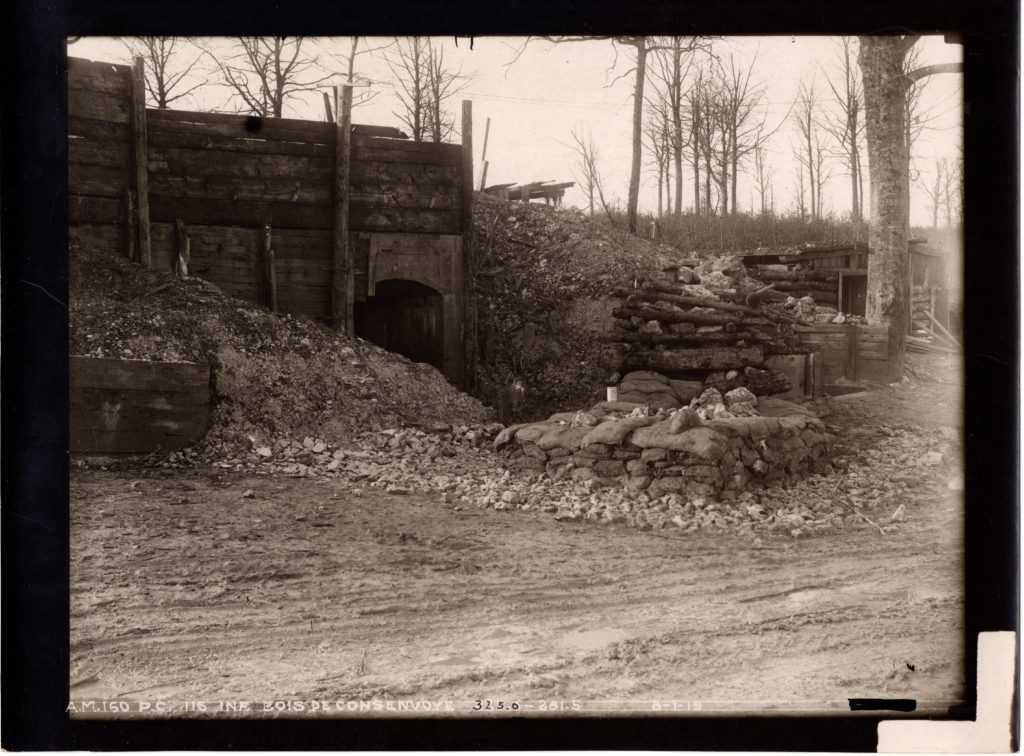
In early 1919 a group of professional Signal Corps photographers under the leadership of Major T.J. Griffin of the Intelligence Section <G-2> of the AEF General Staff took more than 2,300 high-quality b/w photographs of the American battlefields on the Western Front. For years, the “Griffin Group” photo archive remained tucked away in the National Archives; known only to a handful of researchers. In 2017 battlefield historian and tour guide Randal Gaulke viewed this photo collection and was astonished by the level of detail and the range of topics covered. Upon his return from the battlefields in late 2017 he vowed to make them more readily available. In this Q&A session Randal provides more details about this collection.
1) How were you introduced to the collection?
Serendipity, I suppose. In April 2017 I met researcher Marc Romanych at the National Archives. During our conversation he said something like: “If you’re going to be leading tours over there, you need to know about this collection of photos.”
2) What impact did it have on you then?
Once Marc showed me the collection, I quickly changed my priorities for the two-day research visit; and spent most of the next two days scanning about 600 of the 2,300+ photos. That exercise was the closest I have come to “seeing” the Western Front.
3) What is so powerful about the photo collection?
Several things: First, they were taken just months after the war; showing the Western Front before most clearing and re-building. Second, the range of topics covered is phenomenal: battlefield panoramas, military installations, fortification construction, cemeteries and graves, etc. Third, the photos were taken by professional photographers and they are very detailed and clear. Fourth, the map coordinates on most of the photographs can be used to identify their location.
Because of these four points, the photos are great for serious AEF researchers, battlefield visitors, and students of wartime defense construction.
In preparing the collection, I scanned the photographs at 600dpi. Other than rotating the most crooked photos, I did virtually no other retouch to the photographs.
4) What did you do with the photos in France?
It was great to integrate the photos into my various battlefield tours. On more than one occasion, these photos served as “icebreakers” with local citizens, who saw me running around their street looking for just the right match. Many of the photos became a key part of the “Then and Now” posts on this website.
5) How does one use them for a battlefield visit?
The map coordinates printed on most photos use the same coordinate system as found on the maps in the 1944 “Summary of Operations” book series published by the American Battle Monuments Commission. (Because the ABMC maps are in the public domain, a digital copy of the ABMC map is included with the purchase.) Using the photos and maps in combination, one can gain a new perspective when visiting the AEF battlefields.
Most of the AEF battlefields are covered. Unfortunately, there is no coverage for the 27th and 30th Divisions fighting with the BEF and no coverage for the 92nd and 93rd Divisions.
Remember, however, that one does not always find what one is looking for. In many cases buildings no longer exist. In some cases towns / buildings (especially churches) were rebuilt in different locations, etc.
6) Why distribute them? Why not keep them for your own research / publication purposes?
I believe that these photos should be shared with other researchers. There are so many photos and so many topics covered that it would not be right to hoard them. For example, a lot of readers are interested in the amalgamation of U.S. dead into the ABMC cemeteries that we know today. There are perhaps 50+ photos of cemeteries and individual graves. That’s not my area of interest. There are also several photos showing German anti-tank mines–already in WW1!
7) Why just sell them as a collection of photos? Why not publish a book?
I gave book writing a lot of thought over the last twelve months, and I talked to numerous authors, including a few that published “artistic” books on WW1. In the end, the most important thing is to make the photos available to researchers who can use them. Any book would likely have been limited to using perhaps 200 – 250 photos maximum; restricting their availability.
Selling copies directly also eliminates days of negotiation, layout and collaboration with a publisher, or the frustration of self-publishing.
8) But you are selling them to make a profit, right?
I’d like to recover my costs and have a little bit to show for the effort. In total, I spent seven days scanning at the National Archives. After that I spent days cropping the scans, checking and double-checking the naming convention, etc. A good WW1 book sells around 1,000 copies; and this collection of photos likely appeals to a much smaller group than that.
9) What exactly is in the collection?
Readers will find more product details under The Griffin Group Photos tab on my website. Essentially, there are 2,351 photos taken all along the AEF’s Western Front. 1,340 are in the Meuse-Argonne Sectors and 340 in the St. Mihiel Salient. I have included an additional 6 photos that provide details of the collection in the National Archives. I have also included 91 ABMC “Summary of Operations” maps, which are in the public domain. Finally, I have written a brief user guide to help people understand things.
10) How is the collection organized?
Each photo in the collection is a separate .jpg file. I have used a file naming convention that contains most of the details provided on the photo. It looks something like this:
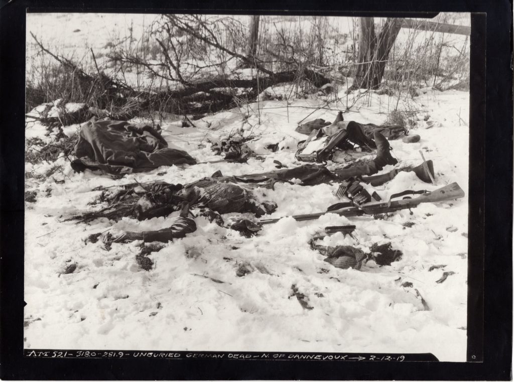
[Number Description Coordinates Date]AM521-80 Unburied German Dead N. of Dannevoux 318.0 – 281.9 2-12-19
11) How large is the collection?
In total, the collection, including the ABMC maps, is almost 13GB of memory! Because the photos were scanned at 600dpi, most individual files are 5-6MB.
12) How do I purchase the collection?
Again, you can find order details on The Griffin Group Photos tab of this website.
The price for the entire collection is $25 / 20 Euros for electronic delivery via Wetransfer. There is an additional fee of $10 / 15 Euros for mail delivery using a USB stick. The additional fee reflects the cost of a 16GB USB stick and postage. International postage from the U.S. is particularly expensive.
Purchasers can pay via cash, check or PayPal.
13) How does Wetransfer work?
When the order is processed, you will receive a total of three emails from Wetransfer. This will allow you to download: 1) the Meuse-Argonne photos, 2) the remaining photos and 3) the ABMC maps.
14) Why do I have to buy the whole collection when I’m just interested in a few photos or a specific region?
Ease for the seller. I originally thought about breaking the collection up geographically, but as more than 50% of the photos are of the Meuse-Argonne, it made little sense. For example, there are 271 photos taken in Alsace.
15) How do I know if there are photos related to the region or unit that I am interested in?
You can always send me an email asking for some details. Without doing an exhaustive research, I’ll give you some idea of the photos available.
16) Do you have your favorites?
I have way too many favorites to list separately! The [AM521-80] photo of the unburied German soldier mentioned above is one of them. In part, because it shows the harsh sentiment of the time. This corpse has been laying there for three months after the war without being buried. Was the hatred so strong? Did the locals, when they started to return, just have higher priorities?
Again, the great thing about this photo archive is that it tells the story of the AEF in yet another way. Its photos also shed some light on the German side of the story too! That is what makes this such a great resource!!!


